
It was an rare mostly sunny day in February, in the northeast of England, when I set out from Middlesbrough via rail to explore the North York Moors National Park. I departed from the Middlesbrough rail station, taking the Northern Rail Esk Valley Line, which terminates in Whitby. During the winter, the line runs four times per day, and I was on the second run, which departs at 10:28am.
The view from the train quickly gives way from the city to rural fields, and as the line enters the park, it turns to rolling, lush green hills, the color of which is especially accentuated if you’re lucky to have sunshine. The entire journey has 16 stops, and takes about 90 minutes if you take it all the way to Whitby.
I departed the train at the village of Egton. It’s a short walk from the station to the Esk Valley Trail, marked by the signs with a salmon. Simply turn right on the main road outside of the station, and the trail begins about 200 feet down the road.

The first leg was a typical farm road, fairly flat, running parallel to the River Esk. After about a mile and a half, I reached the crossroads village of Grosmont. From here, a more grueling three and a half mile leg begins to get to the village of Sleights.
At first, it is the same style farm road, which took me through the middle of a working farm, full of sheep dogs (tied up, so don’t let the barking scare you), sheep, and free range chicken and geese. This is the only place I saw another human being along the trail between towns, a woman working on that farm. We exchanged waves as I walked by. Then, as I exited the farm, suddenly the path diverged into a wooded hiking trail.

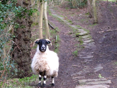
This is where I had to start shedding some layers. Despite the slight wind and the 40 degree temperature, the air in England is always rather damp, thus making it seem a bit warmer than it actually is, especially when you are walking uphill. I was down to my wind coat and a T-shirt at this point, as I encountered a pair of rams, grazing in the brush alongside the trail. One scampered off into the woods, but the other stood firm, staring me down, almost daring me to pass through. I called his bluff, and after a polite shooing, he gave way.
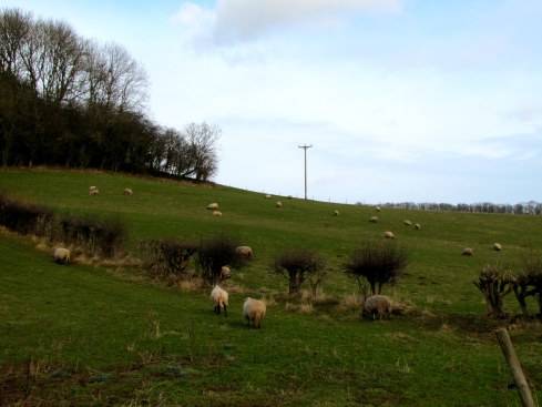
As I exited the woods, I came to an open field. Staying along the fence line, I found the path continued on the other side. This field was a preview of what was to come: a bit damp, mucky and full of sheep piles, like walking through a minefield.

The next part of the trail became especially grueling, and not in a typical way. The trail is mostly downhill, however, since this is England, and it was winter, the trail was a washed out, muddy mess. Compounding matters is that it is surrounded on both sides by thick briar patches. If you find yourself tumbling, which I almost did about six or seven times, your choice is to fall into the mud or the briar patch. There simply isn’t any way around.

Once through this harrowing section, the muck didn’t decrease, but the grass at least helped me maintain balance. The journey is through multiple sheep fields, all of which were mucky, especially around the gates leading to the next field. At two of these gates, I opted to carefully climb over the fence in an attempt to reach the least mucky way through.
When I finally arrived in Sleights, I got a bit lost. The signs were not clearly marked to indicate the trail, so I ended up walking down The Carrs (B1410), thinking this was the way. Unfortunately, as the village ends, so does the sidewalk, leaving me walking on the shoulder, which at times is quite narrow. Luckily it was only about a mile to the next village, Ruswarp. This is where the River Esk turns from rapids to tidal. Here I quickly found an open pub, The Bridge Inn. I was quite hungry at this point, but food didn’t start until 4:00pm. I opted for a snack of some crips and a pint of ale, and enjoyed both while sitting fireside. The woman at the bar directed me to the trail between Ruswarp and Whitby, and told me I would be there in about 30-40 minutes.

The final leg of the trail runs exactly between the rail and the river, providing spectacular views of the river as it becomes larger, and boats are now running up and down. It goes under a massive viaduct style bridge which carries not a motorway, but astoundingly a bike trail which runs along the seaside through the park.

Finally to the town of Whitby, and to the pier. Going far out into the North Sea and ending with a pair of lighthouses, the pier is a popular attraction during the summer. However, by the time I arrived at Whitby, it was drizzling, high tide, and the waves were pounding against the pier and the seawall, completely covering Whitby Beach. Beware of this, as waves are prone to jump over the pier during this time, which could result in an unpleasant soaking.


The last part of the journey involves finding some fish and chips, and of course, a few pints of ale. Whitby is known as the cod capital of the United Kingdom, so this is the specialty dish here. During the off-season, most of the fish and chip shops are closed, and many of the pubs that remain open do not serve food until Thursday through Sunday. I found one that was fully operational, The Granby Hotel, and had the largest fish and chips platter I’ve ever seen, complete with mashed peas, slaw and salad. After devouring this, and downing a few pints, I departed for my train back to Middlesbrough, a night journey which departs at 7:19pm, and also takes about 90 minutes.
If I can offer some advice and some “lessons learned” for future travelers on this hike: wear good, preferably waterproof hiking shoes or boots, ones that may need to withstand up to ankle level muck; bring water, and snacks; and dress in and/or bring layers, including a rain shell. The climate changed considerably along the way, going from sunny and a mild feeling 40 degrees, to a bit colder, rainier and windy as I reached the tidal areas closer to Whitby. A walking stick may not be a bad idea either, for those washed out sections of the trail. Finally, be sure to download or print out a map guide from the park service, so you can find the trail and not end up trekking down a highway if the signs are not clear.
My route was about 14.5 kilometers, or about nine miles, and with the pub stop in Ruswarp, took about four hours. One can choose to do longer or shorter by getting off at an earlier station than Egton, or a later station. And always end up with a fish and chips platter and a pint of ale before taking the return train!

Thanks for the tips Alex – sounds fun!
LikeLike
Alex, I am so impressed with your writing and photography skills. I felt as if I was there! You must keep up your writing as you move through the world. I believe you have something very special to offer. Always knew you did when you were recognizing Ronald Reagan as President on TV when you were 2 were reading all those wind directions off PopPop’s wind gauge.
LikeLike